

The Cotswold Way
The Cotswold Way is a National Trail which runs for 102 miles (163 km) from Chipping Campden to Bath. For much of its course, it follows the Cotswold escarpment and gently winds its way southward through picturesque villages, open farmland and beech woodlands until it reaches the historic city of Bath.
The entire length of the route was photographed from the air in 1991. This feature highlights some of the most striking landmarks along the Way.
|
1. Chipping Campden
The Cotswold Way starts at the marker stone beside the town hall in Chipping Campden, one of the most picturesque towns in the Cotswolds. After following the curving high street of this market town, the route ascends to Dover's Hill, where walkers reach their first viewpoint of the Way. |
 |
|
2. Broadway Tower
The 18th century folly of Broadway Tower stands at the top of Beacon Hill, one of the highest points of the Cotswolds, at 1,024 feet (312m). Fine views of the route ahead to Stanton can be had from its viewing gallery. |
 |
|
3. Belas Knap Long Barrow
South of Winchcombe, the Way passes the neolithic long barrow of Belas Knap. First excavated in 1863, this large chambered cairn contained the remains of over 30 people. |
 |
|
4. Cleeve Common
Switching back northward, the Way loops around the windswept plateau of Cleeve Common, an area of 2 square miles of limestone grassland. The Common is a Site of Special Scientific Interest and is managed by a Board of Conservators established by an act of Parliament in 1891. The Way follows the scarp edge and crosses the hillfort seen in this image. |
 |
|
5. Devil's Chimney
South of Cheltenham, the Way passes the iconic Devil's Chimney, a distinctive rock pillar thought to be a relic of quarrying of the limestone scarp. Stone from this location was used to build the Regency terraces of Cheltenham. |
 |
|
6. Painswick
Walkers pass around the quarried remains of the Iron Age hillfort on Kimsbury Hill before arriving in the town of Painswick, known as the 'Queen of the Cotswolds'. |
 |
|
7. King's Stanley
Alongside quarrying, textile manufacturing was a major industry in the Cotswolds in the 18th and 19th centuries. The five-storey mill at King's Stanley was built in 1813 using stone, brick and cast-iron to minimise the risk of fire. |
 |
|
8. Cam Long Down
At Cam Long Down, the walker can experience 360-degree views, taking in the Cotswold escarpment and the Severn Plain below. The adjacent Peaked Down offers another all-round viewpoint before descending into the town of Dursley. |
 |
|
9. Old Sodbury
The Iron Age fort east of Little Sodbury was later re-used by the Romans and Saxons and also provided a secure camp site for the army of King Edward IV before the Battle of Tewkesbury, during the War of the Roses in 1471. |
 |
|
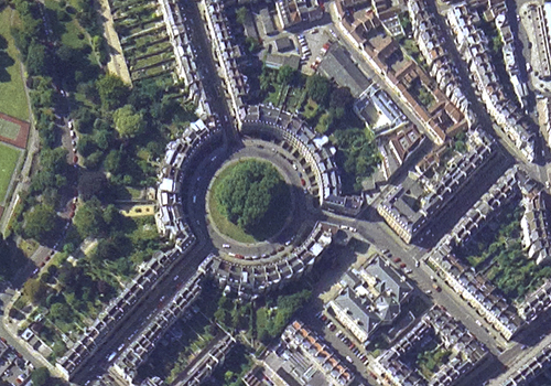
10. Bath
The final stretch of the route leads through the suburbs of Weston before reaching the dignified Georgian terraces, parades and crescents of Bath. People have been visiting Bath since Roman times, and the city provides a fitting terminus for the Cotswold Way, allowing the walker to reflect on their achievement before seeking refreshment, accommodation or homeward transportation.
|
 |