

How to read Finding Aids
Sortie plot finding aids are maps annotated with information about where aerial photographs were taken during a reconnaissance or survey mission, and the ground area they cover. They are the key to identifying millions of undigitised aerial photographs held in NCAP.
All of our catalogued finding aids are accessible on the NCAP website. To see what is available, Browse by Map to zoom to your area of interest and then click on 'See finding aids in this area'. For help, see our Guide to Searching.
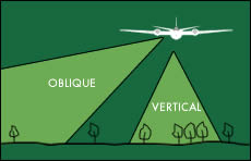 |
The example sortie plots shown below all record the collection of vertical aerial photographs, taken by cameras directed at a perpendicular angle to the ground below the aircraft, to give a plan view similar to a map.
The vast majority of aerial photographs taken around the world, and held by NCAP, are vertical.
|
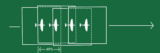 |
When looking at individual sortie plots on the website, you will see that one photograph covers much of the area seen in the next photograph in the sortie.
Vertical aerial photographs are normally taken with a 60% overlap between frames along the line of flight. This allows for stereo viewing of features in 3-dimensions.
|
Sortie plot finding aids exist in a variety of formats - an explanation of the most common appears below.
|
Topographic Cover Plots
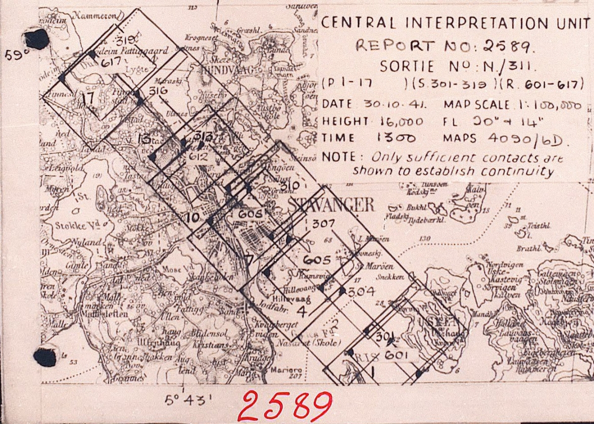
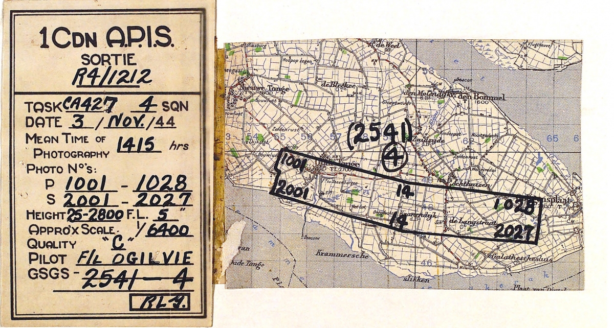
Sortie plots created by plotters at the Allied Central Interpretation Unit (ACIU) during the Second World War were usually drawn onto topographic base maps. Each plot shows the area photographed during a reconnaissance mission, annotated with polygons representing the ground covered within individual photographs. To reduce cluttering the map, only every second or third frame in each strip of photographs is drawn.
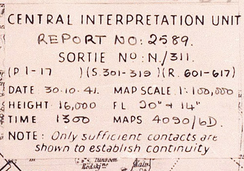
Included on each sortie plot is a label containing information about the sortie. The Medmenham Library reference number for the sortie (2589 in this example) also appears in the margin.
|
 |
|
The data label records the sortie reference, the date and time of photography and the frame numbers of the photographs taken by each camera. Also included are the flying height of the aircraft and the focal lengths of the cameras carried, along with details of the base map used for plotting. |
 |
|
The coverage obtained by the cameras on board the aircraft will normally overlap at the edges, allowing the aircraft to cover a wide swath of ground in one pass over the target. It is helpful when orientating photographs to note that the small infill at the corner of a frame drawn on the sortie plot corresponds to the position of the frame number on the photograph.
In this example, the Hillevaag area to the South-East of Stavanger would be covered by frames 4 and 605. As these photographs are from different number sequences, it is likely that they were taken by different cameras. A check of the data label confirms this: frame 4 was taken by the Port camera and frame 605 by the Rear camera. The label also shows that these cameras had different sizes of lens, meaning that the photographs taken by each will be at different scales.
|
 |
|
As the number of photographic reconnaissance sorties increased during the second half of the war, the art of cover-plotting was refined. In order to increase output, plotters would often record sorties by only showing the first, an intermediate, and the last frame in a photo run and then joining them by parallel lines to show the coverage of the run.
|
 |
|
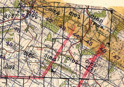
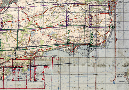
In the Post-war period, cameras were installed within the aircraft in 'fans' of 2, 4 or 6 cameras. To differentiate between the images from each camera in a two-camera fan, the photo frames were given the prefix F21 or F22. In the sortie plot opposite, the photographs run from east to west, beginning with frame F21: 0100 on the left of the aircraft and frame F22: 0100 on the right.
|
 |
|
In a four-camera fan, the photo frames from each camera are prefixed by F41, F42, F43 and F44. In the sortie plot on the right, the photographs run from east to west, beginning with frame 0406. The camera positions are colour-coded, with F41 on the extreme left of the aircraft, F42 and F43 in the centre and F44 on the extreme right.
|
 |
Trace Overlays
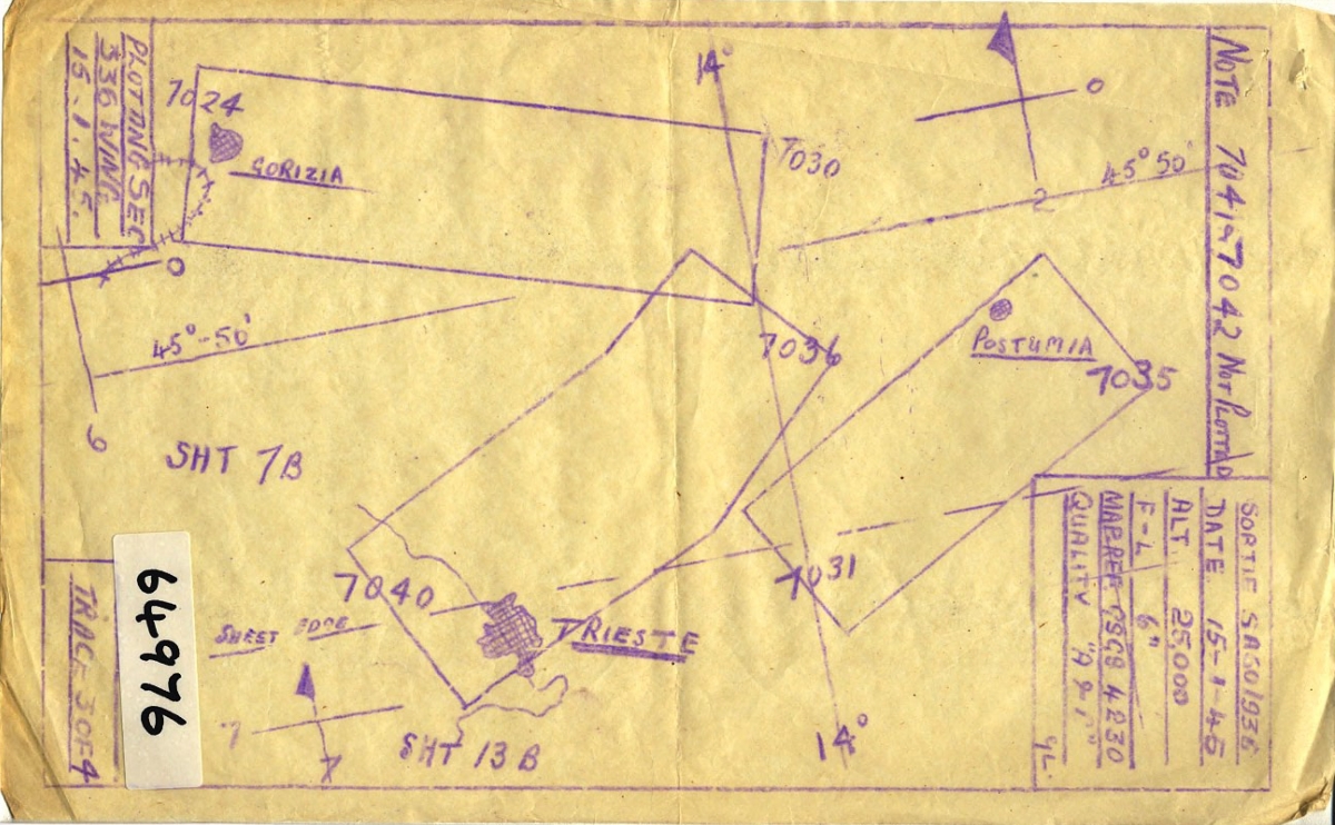
Sortie plots covering the Mediterranean theatre, drawn by plotters serving in North Africa, Malta and Italy, were drawn onto topographic base maps and trace overlays. To orient trace overlays with their GSGS base map, the nearest grid lines are also recorded (please note that NCAP does not hold these base maps).
As at ACIU, relevant sortie information appears in the corner of the plot.
|
 |
Linear Cover Plots
The location of photography collected during commercial aerial survey sorties is normally recorded by drawing the line of flight on a base map or trace overlay and then marking the centre of each photograph taken along this line with a symbol.
The example shown here is from the All Scotland Survey, flown in 1987-1989.
|
|
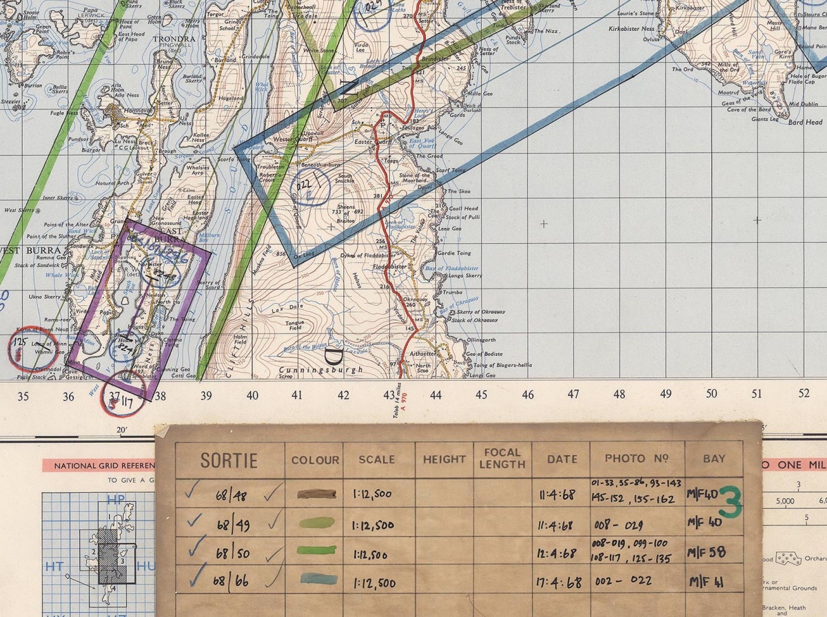
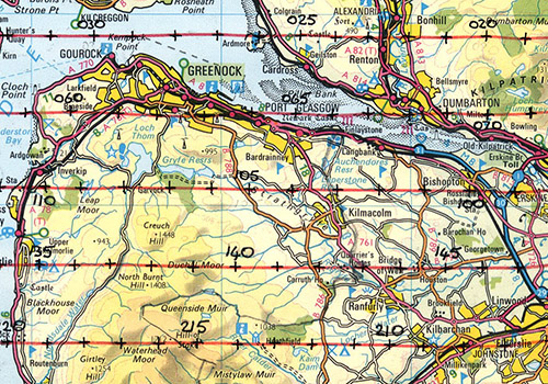
Ordnance Survey Flight Diagrams
Aerial photography of Scotland flown by and for Ordnance Survey before the mid-1970's was plotted on OS 1:63,360 (One Inch to the Mile) base maps by staff at the Scottish Office Air Photographs Unit. The ground footprint of each sortie was drawn on the map in a unique colour, indexed in a key pasted to the foot of the map. Within the footprint, individual flight lines were drawn in the same colour and frame centre-points were marked at intervals of 5 or 10 frames.
|
 |
|
From the 1970's onward, Ordnance Survey used 1:50,000 scale base maps to record its aerial photographic coverage of 20km x 10km blocks. On these diagrams, each sortie has a unique symbol to show the centre-point location of each image taken. The date, altitude and camera focal length of each sortie is given in the adjacent key.
For more information, see our feature on How to use OS finding aids.
Contains OS data: Ordnance Survey licence 100020548. All rights reserved. © Copyright and database right 2015. |
 |
Photo Lay-downs
Created by the Directorate of Overseas Surveys to illustrate and understand the aerial photographic coverage obtained for mapping projects, Photo Lay-downs (PLD's) often show the sortie and frame references of their constituent images at the edges of the PLD. They can therefore be used as a finding aid to the original photography of a particular area.
The example shown here is from a survey of Kenya flown in 1959.
|
 |
 |
When using the Finding Aids, you will see that our holdings of non-UK imagery are catalogued to the boxes of 10-minutes of latitude and longitude they cover. Degrees are subdivided into minutes of latitude and longitude, where one degree square is 60 minutes x 60 minutes. As these boxes differ in size depending on where they are on the globe, some 10-minute boxes will have many sorties catalogued to them.
To find an image of a particular place, you must look through all of the sortie plots returned for the 10-minute box in which your general area of interest falls. It is important to note that not all of these sorties will cover your specific area of interest within a particular box, however.
|
Ordering Copies of Frames
Copies of frames identified from finding aids can be ordered at various resolutions. See our price-list for options.
When ordering images from sortie plots, we recommend ordering the frame identified (e.g. 5050) plus the frames on either side (e.g. 5049 and 5051) to ensure that your area of interest is covered.