View unseen images of Scotland's countryside, towns and cities in the 1940s and 1950s.
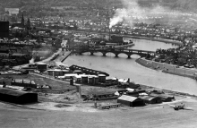
280,000 images were taken during 500 sorties across the length and breadth of the country during Operation Revue. Running from 1945 to 1951 it was not only a means to gainfully employ RAF pilots and aircrew in peacetime, but also created an invaluable blueprint for the planners and architects engaged in producing a vision for the future development of Scotland.
These photographs, many of which have never been seen before by the public, now form the basis of the Scotland section of the National Collection of Aerial Photography, an archive of millions of aerial images held by RCAHMS. You can now view digital copies of the historic images and plot their locations on modern satellite images and maps of Scotland.
Available to view online now are images that informed the development of the 'New Towns' of East Kilbride, Cumbernauld and Glenrothes; shots of central Edinburgh landmarks like St Andrew's Square, the Balmoral Hotel and Princes Street Railway station 20 years before it was demolished; a sortie along the River Clyde from Finnieston to Clydebank showing the busy shipyards; Aberdeen, Dundee and Inverness in 1947; and images of towns across Scotland in the late 1940s and early 50s from Paisley, Perth, Stirling, Dumfries and Dumbarton to Hamilton, Kilmarnock, Kirkcaldy and Greenock.
Manager of the National Collection of Aerial Photography, Allan Williams said: These unique photographs show Scotland's countryside and towns on the cusp of tremendous change. At one extreme, you can see long-gone industries like jute and shipbuilding dominating town and city centres. At the other, it's the small things that have amazing resonance - for example, horses and carts were still commonplace sights in Scotland's towns in the 1950s, something that many might find hard to believe today.
These images were also a key information resource that informed the creation of modern Scotland. Government planners wanted the most up-to-date overview of what the whole of the country looked like. Obviously there was no satellite technology at that time, so they relied on the unique skills of the reconnaissance pilots to create this comprehensive record.
As well as the thousands of shots that make up Operation Revue, there are over a million images of Scotland in the National Collection of Aerial Photography. More photographs from this unique resource are being added to the website all the time, and a dedicated search area within the RCAHMS Edinburgh headquarters allows anyone to consult aerial imagery of every inch of Scotland.