Wartime European cities now online
From Berlin in 1941 and German-occupied Amsterdam in 1943, to Rome in 1944, a free Paris in September that same year and Liberation Day in Copenhagen in 1945, you can now view stunning historic imagery of Europe's major cities online.
Landmarks including the Brandenburg Gate and Tempelhof Airport in Berlin, the Eiffel Tower and the Palais de Chaillot in Paris, and the Coliseum and Castel San Angelo in Rome are all clearly visible in digital copies of aerial reconnaissance photographs taken during the Second World War.
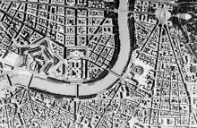
As well as being able to view individual frames, RCAHMS are using cutting edge technology to piece together sequences of photographs to create historical mosaics of major cities and overlay them on modern maps to allow for direct comparisons. Rome in Italy and Toulon in France are the first city mosaics to be put together and are available to view for free for a limited period before they revert to a subscription-only service.
The imagery used to create the mosaics of Rome and Toulon came from the same reconnaissance sortie flown by the Royal Air Force on 20 August 1944. The coverage of Toulon is particularly striking, showing large plumes of smoke drifting from damaged buildings, oil-slicks from sunken warships smeared across the waters of the harbour, and the many bomb-craters that had devastated the dock-sides of this strategically important Mediterranean port. These photographs were taken on the same day that Toulon was attacked by Allied forces as part of Operation Dragoon, the plan for the invasion of Southern France. Eight days later, on 28 August 1944, the German command surrendered and Toulon was liberated.
The creation of these mosaics is possible because reconnaissance aircraft often used multiple cameras to produce photography that overlapped around 60 per cent in every compass direction. These stereo photographic techniques allowed photographic interpreters to view imagery in 3D, which had a huge impact on the level of detail they could include in their intelligence reports.
Andreas Buchholz, GIS and Research Curator for the National Collection of Aerial Photography said: These seamless, georeferenced mosaics demonstrate very effectively the power of historical aerial photographs. Users can switch between layers showing different time periods to quickly appreciate changes at any location. They can make accurate measurements of areas and distances, and are able to compare it with mapping which underpins the mosaic. Imagery from our collections and these analysis techniques are used extensively by specialist researchers in their work. We hope this new website will make the imagery accessible to an increasingly wide range of users.
More European city imagery is being added to the website by the RCAHMS team all the time. The next city mosaic to be released will feature Glasgow.