You are here

Erased Landscapes

Funding from the European Union ArchaeoLandscapes project has enabled NCAP and academic partners in Poland to collaborate in the identification and digitisation of over 160 German Air Force aerial images of parts of Poland, Belarus and Ukraine taken during the Second World War. This work has allowed researchers in Poznan and Szczecin to study the landcape of parts of Poland in the 1940's. The results of some of this work can be seen in the two case studies below.


Głogów Case Study

Grzegorz Kiarszys - Szczecin University Institute of History and International Relations, Department of Archaeology

 
Comparison and interpretation of differences between contemporary and historical aerial photographs makes us aware of the fact, that 20th century landscape transformations were especially extensive and dynamic. Such an approach can be useful in the studies of the impact of ideology on the shape of cultural landscape as in the example of Głogów city (Lower Silesia Region, Poland) presented below.
 
Following orders issued in July 1944 by Adolf Hitler, Głogów was turned into a fortress, and during the last months of the Second World War in Europe it shared the fate of many other towns of strategic importance. After months of preparation the city was desperately defended against the advancing Red Army. 
 

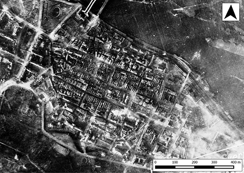
This German aerial photograph of Głogów, taken on 16 March 1945, records in great detail the extent of devastation. Only a very few buildings still have roofs, others are only burnt-out shells. Most of the architecture is already ruined. The smoke rising over the city indicates that some of the buildings are on fire.


The next days of the siege brought complete destruction of the city. Air raids, artillery barrage and heavy street fighting turned it into rubble. Finally, after six weeks of siege, on 3rd April 1945 the city was officially surrendered to the Red Army.

During the Communist era very few buildings were built within the historical city centre of Głogów. Even until very recently the larger part of the old city was empty and ruins were still visible.


Most of the towns of contemporary western Poland, that happened to be located in the frontline areas, shared very similar destinies. After the war they either underwent extensive transformation or were completely demolished. Most of them were never restored to their previous state. The aim of post war ‘reconstruction’ in Communist Poland was more about transforming the landscape so it could fulfil the new ideological requirements than about restoring the old spatial patterns. 


Defence in the rhythm of Richard Wagner's music. The last days of 'Fortress Küstrin'

Grzegorz Szalast and Grzegorz Kiarszys - Szczecin University Institute of History and International Relations, Department of Archaeology


Kostrzyn (German Küstrin) is located at the confluence of the Warta and Oder rivers. Since 1537 the town was gradually transformed into a mighty fortress. The stronghold of Küstrin gained its final shape in the second half of the 19th century. Since that time the spatial plan of the town received its characteristic irregular hexagonal shape surrounded by six bastions.       
 
At the turn of the 20th century the fortifications lost their military importance and were gradually dismantled. That situation substantially changed on the 28th of November 1944, when German general Heinz Guderian ordered new fortification works to be built. On the 25th of January 1945, Küstrin was officially declared the stronghold of Third Reich. It became the Gates to Berlin, an important strongpoint on the Nibelungs' Line (German Nibelungstellung). The Nibelungs' Line was a romantic metaphor inspired by Germanic mythology. 
 
Küstrin was located in a very convenient defensive position. The proximity of two major rivers and the vast marshlands surrounding the town produced very difficult conditions for the approaching Red Army soldiers. During the winter, the frozen River Oder could be crossed by Red Army troops but the ice was too thin to allow tanks and rocket launchers to pass. 
 
The strategic situation of Küstrin changed on the 31st of January 1945 when Soviet troops gained a bridgehead on the western bank of the Oder, about 17 kilometres to the north from the town, in the region of Kienitz village. During next few days another lodgement was secured on the western bank about 10 kilometres to the south, near Górzyca village. During the spring thaw, the ice melted and the level of the water table rose enough to cover the Red Army’s bridges over the Oder with 25-30cm of water. For a while they became 'invisible' to Luftwaffe reconnaissance aircraft. 
 
In the first half of March 1945, after a month of fighting, the Red Army captured the New Town district of Küstrin. Josef Stalin was convinced that the siege was over. He congratulated the soldiers in his Order No. 300 and decorated some of them with badges. Soviet propaganda began to celebrate the victory. However, heavy fighting for the old part of the town continued until the 30th of March 1945 when the fortress of Küstrin was surrendered.
 
 
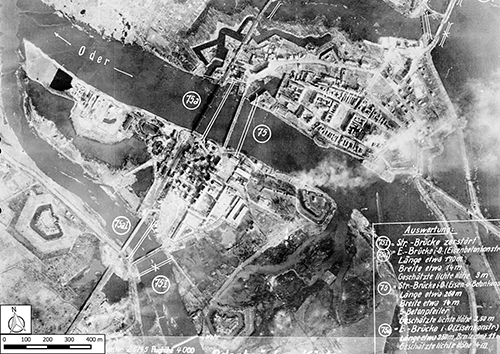
The Fortress of Küstrin. German aerial intelligence photograph taken on 13 March 1945.
 
The example of the wooden bridge built by the Red Army engineering troops within just several days. The photograph on the left was taken on 08 April 1945, while that on the right was taken on 11 April 1945. 
This photograph from 08 April 1945 shows a system of trenches built by Red Army soldiers on the west bank of the River Oder. 
On the left, a German topographical map from 1936. On the right, the Soviet map from 1949. 
 
The siege of Küstrin lasted for almost 60 days. German casualties numbered 637 killed and 5995 missing while the Red Army lost around 6000 soldiers in the battle. For the Soviets, the fall of Küstrin opened the way to Berlin, only 80km to the west. 
 
The heavy street fighting had caused massive destruction to Küstrin. After the war the town was placed under Polish administration. The decision was made to not rebuild the old town and bricks from demolished buildings were collected and transported for the rebuilding of Warsaw. Rocket and engineering troops were based in a depot within the New District of town and for many years afterwards Kostrzyn became a restricted area.


The target of the ArchaeoLandscapes project is to address existing imbalances in the use of modern surveying and remote sensing techniques and to create conditions for the regular use of these strikingly successful techniques across the Continent as a whole. It aims to create a self-sustaining network to support the use throughout Europe of aerial survey and 'remote sensing' to promote understanding, conservation and public enjoyment of the shared landscape and archaeological heritage of the countries of the European Union. 


The project ArchaeoLandscape Europe is funded by the European Union within the framework of the Culture 2007-2013 framework (CU7-MULT7, Strand 1.1 Multi-Annual Cooperation Projects).