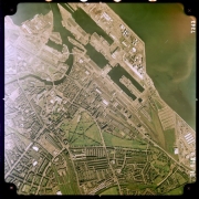
Historic aerial photography is an excellent source for identifying those features that may not be shown on a map. For locations in Scotland, NCAP offers an extensive range of historical aerial photographs that can aid in site analysis, allowing for the identification of previous land and property uses which could lead to environmental impact on a site in the present day.
This feature uses a selection of images of Leith docks to illustrate the variety of image types and sources available for just one location, tracking developments in the area from 1939 to 2010.
| Vertical aerial photograph taken by the German Air Force on 2 October 1939. |
 |
| Vertical aerial photograph taken by an aircraft of No.1 Photographic Reconnaissance Unit, Royal Air Force, in June 1941. |
 |
| Oblique aerial photograph taken by an aircraft of No.1 Camouflage Unit, Royal Air Force, in October 1941. |
 |
| Vertical aerial photograph taken by the Royal Air Force during the post-war National Air Photograph Survey in June 1946. |
 |
| Oblique aerial photograph taken by the Royal Air Force in December 1951. |
 |
| Vertical aerial photograph taken by the Royal Air Force in 1961. |
 |
| Vertical aerial photograph taken by the US Navy in July 1966. |

|
| Vertical aerial photograph taken by Meridian Airmaps Ltd in July 1971. |
 |
| Vertical aerial photograph taken by Fairey Surveys Ltd in May 1975. |
 |
| Vertical aerial photograph taken in June 1988 by J A Story Ltd, one of two commercial survey companies commissioned by The Scottish Office to survey all of Scotland. The complete survey, over 14,000 images, is available to view on this website. |
 |
| Oblique aerial photograph taken by Edinburgh Air Centre Ltd in July 2003. |
 |

