Police Investigation

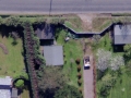
NCAP aerial photography has been used by several divisions of Police Scotland when reviewing cold cases and in long-running investigations.
In the intervening years since the date of an incident, a crime scene may have been landscaped, built on or removed. Historical aerial imagery of locations of interest, photographed on specific dates, has been used by detectives to understand the wider context of a crime scene at the time of the incident, to test observations and statements, to check lines of sight and to examine access and egress routes to and from the crime scene. Aerial photographs can depict the locations of features that are central to a case and they can provide additional detail not shown on traditional maps.
Boundary Disputes
Our aerial photography of Scotland spans 80 years, making it a useful tool in boundary litigation in Scotland.