

OS Photomaps
In the late 1940's a series of photomaps of selected areas of the UK were published by the Ordnance Survey. Created from Royal Air Force aerial photography, they were intended to substitute for large-scale mapping, which was in short supply following the Second World War. They were needed for vital planning and reconstruction work in areas which had suffered wartime damage or change.
The Photomaps are mosaics of several aerial photographs combined into one large overall view, which was then rectified to make them map-accurate before printing along National Grid mapsheet lines at scales of 1:10560 and 1:1250. The mosaics were initially intended only for government departments but were eventually offered for sale to the public in an attempt to recover some of the costs of producing them. Sales of the photomaps were poor, however, and concerns about national security eventually led to their withdrawal from sale completely.
Censorship and sanitisation
| When the photomaps were first published, in the early years of the Cold War, concerns were raised that every detail of important military installations, such as Prestwick airfield, could be clearly seen by the public for the first time. And if the British public could see them, then so could anyone else. |
|

| In an attempt to allay security fears, from 1950 edited mosaics were re-issued for key points, including Prestwick. For sensitive locations such as this, a fake landscape of fields and hedgerows was carefully drawn in, or the site obscured by false clouds. In March 1951, libraries were warned that the original 'true' mosaics should be withdrawn from public use. |
|
| This image shows Turnhouse airfield, west of Edinburgh, photographed during the National Air Photograph Survey in 1946. Photographs from this survey were used by Ordnance Survey to create the mosaics, which were published along mapsheet lines as photomaps. |
|

| This OS Photomap of the Turnhouse area was created from aerial photographs taken in 1946. Note that the airfield, an operational RAF station at the time, has been painted over with a fake pattern of fields and hedgerows. |
|

| This image shows Torry coastal defence battery in 1945. This battery guarded the approaches to Aberdeen harbour during the Second World War. |
|

| The OS Photomap of the Aberdeen coastline was produced from photography flown in 1944. Torry Battery was considered to be of military importance and has been 'removed'. Sanitised photomaps are identified by the small letter 'B' in the lower left corner. |
|

Post-war Housing Expansion
| The area of Lanarkshire farmland depicted here was selected in 1947 as the site for East Kilbride, one of 5 new towns to be built in Scotland to alleviate a shortage of housing in Glasgow following the Second World War. |
|

|
East Kilbride in 1988, following construction and expansion over the intervening decades. |
|

|
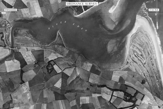
Farmland near Leslie in Fife was selected to be the site of another New Town, Glenrothes. |
|

| The same area seen in 1988 showing Glenrothes, built between the villages of Leslie and Markinch. |
|
