Bedfordshire aerial images released
Over 5,400 aerial images of Bedfordshire are now accessible on the NCAP website. Digitised in collaboration with Central Bedfordshire Council, the images date from 1968 to 1996.
Website subscribers can now zoom-and-pan images of the entire local authority area.
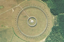
Included in this release are photographs of a signals intelligence facility at Chicksands. During the Cold War, this was the site of a large circular antenna, called a Wullenweber array. Due to the clandestine nature of the facility, the photograph from 1986 was sanitised to remove all trace of the antenna from the image.
10 December 2017


