New wartime aerial photographs of Scotland accessible
During the Second World War, intelligence gathered by photographic reconnaissance units based in Scotland informed some of the conflict's most significant actions. The sortie flown out of RAF Wick by Flying Officer Michael Suckling - which located the German battleship Bismarck in a Norwegian fjord and led to its sinking just days later - was just one of many similar missions. To prepare for these sorties, extensive training flights were made around the United Kingdom. Now another 4000 aerial photographs taken over Scotland during these flights have been preserved, digitised and catalogued, bringing the total resource available online to over 7000 images.
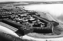
The photographs were taken between 1940 and 1943 and contain unique images of Scotland at war. Highlights of the newly-digitised imagery include military camps and airfields, coastal defences and images of amphibious landing training in progress. These photographs were once held by M Section at the Allied Central Interpretation Unit, RAF Medmenham - the department responsible for aerial photographs of the United Kingdom during the Second World War.


